
WorldRiskIndex – The science base
Aim & Concept
WorldRiskIndex – The science base
|
Aim of the WorldRiskIndex The demand for information and understanding on natural hazard related risk on a global scale has grown in recent years. Such information is crucial for stakeholders who are working in the field of disaster risk reduction, spatial planning and (re-)insurance. The WorldRiskIndex provides a new approach to assess risk and vulnerability towards natural hazards on country scale and allows the comparison of countries at global scale. The index is the product of a close cooperation between scientists and practitioners, it was developed by Birkmann and Welle (see Birkmann et al. 2011, Welle et al. 2015) for the Bündnis Entwicklung Hilft (The Alliance Development Works) aiming at serving as an instrument that helps to assess, visualize and communicate different levels of exposure, vulnerability and risk. Another cooperation partner is the United Nations University-Institute of Environment and Human Security (UNU-EHS). |
|
|
Concept of the World Risk Index The concept of the WorldRiskIndex is referring to the understanding of risk within the natural hazards and disaster risk community, where disaster risk is defined as the product of the interaction of physical hazards and the vulnerabilities of exposed elements (UNISDR, 2004; Wisner et al., 2004; Birkmann 2006, IDEA 2005, IPCC 2012). |
|
 |
|
Data and Methods Final Structural components and indicators of the WorldRiskIndex (click for pdf view)
|
|
|
Calculation of exposure The WorldRiskIndex clearly prioritises those hazards that are widely spread around the globe and account for major harm in terms of people killed. For the period of 1980 to 2010, the most frequent and devastating natural hazards reported were floods, storms, earthquakes and droughts, accounting for 81% of all events and 83% of all reported fatalities (see CRED EM-DAT 2012). Additionally, sea level rise was taken into account since it is very likely that due to further climate change sea level rise will affect many low laying coastal zones and delta regions, since already today 13% of the world population is living in coastal areas that are less than 10m above sea level (UNHABITAT 2011). Exposure relates to physical exposure, which means the potential average annual number of individuals who are exposed to earthquakes, storms, droughts and floods (Peduzzi et al, 2009). These data were obtained from the PREVIEW-Global Risk Data Platform (http://preview.grid.unep.ch/), which is a multiple agency effort to share spatial data on global risk regarding natural hazards. The calculation of exposure to sea level rise by one meter is based on data from the Center for Remote Sensing of Ice Sheets (CreSIS, 2011) at the University of Kansas and population statistics of the Global Rural-Urban Mapping Project (GRUMP) run by the Center for International Earth Science Information Network (CIESIN, 2012) at Columbia University and was derived by using GIS (Geographical Information System) methods.
|
|
|
Calculation of susceptibility (click for pdf view)
|
|
|
Calculation of lack of coping capacity (click for pdf view)
Lack of Coping Capacity (LoCC)=1-CC |
|
|
Calculation of lack of adaptive capacity (click for pdf view)
Lack of Adaptive Capacity (LoAC)=1-AC |
|
|
Calculation of the WorldRiskIndex WorldRiskIndex =E*((1/3)*(S+LoCC+LoAC) |
|


|
Results (click to open interactive view)
|
|||||||


|
Birkmann, J., & Welle, T. (2016): The WorldRiskIndex 2016: Reveals the Necessity for Regional Cooperation in Vulnerability Reduction. In: Journal of Extreme Events, Vol. 3, No. 1, (21 pages). Welle, T., & Birkmann, J. (2015): The World Risk Index – An approach to assess risk and vulnerability on a global scale. In: Journal of Extreme Events, Vol. 2, No. 1, (34 pages). Birkmann, J. and T. Welle (2015): Assessing the risk of loss and damage: exposure, vulnerability and risk to climate-related hazards for different country classifications; International Journal of Global Warming 01/2015; 8 (No.2):191-212. Birkmann, J. and T. Welle (2015): Assessing the risk of loss and damage: exposure, vulnerability and risk to climate-related hazards for different country classifications; International Journal of Global Warming 01/2015; 8 (No.2):191-212. Welle, T., & Birkmann, J.(2015): Der WeltRisikoIndex 2015. In: WeltRisikoBericht 2015, HRSG. Bündnis Entwicklung Hilft und United Nations University-Institute for Environment and Human Security, pp. 41-49, ISBN 978-3-9814495-8-7 Welle, T., Beck, M., Birkmann, J.: (2014): The Coasts at Risk Index. In: Coasts at Risk: An Assessment of Coastal Risks and the Role of Environmental Solutions. Edited by Michael W. Beck. A joint publication of United Nations University - Institute for Environment and Human Security (UNU-EHS), The Nature Conservancy (TNC) and the Coastal Resources Center (CRC) at the University of Rhode Island Graduate School of Oceanography. Published 2014. Welle, T., Birkmann, J., Rhyner, J. (2014): Der WeltRisikoIndex 2014. In: WeltRisikoBericht 2014, HRSG. Bündnis Entwicklung Hilft und UNU, pp. 39-53, ISBN 978-3-9814495-3-2 Welle, T., Birkmann, J., Krause, D., Suarez, D.C., Setiadi, N. and J. Wolfertz (2013): The WorldRiskIndex: A concept for the assessment of risk and vulnerability at global/national scale. In: Birkmann, J.: Measuring Vulnerability to Natural Hazards: Towards Disaster Resilient Societies. Second Edition, pp. 219-251, United Nations University Press. ISBN-13: 978-92-808-1202-2 Birkmann, J., Cutter, S., Rothman, D., Welle, T., Garschagen, M., van Ruijven, B., O‘Neill, B., Prestion, B. L., Kienberger, S., Cardona, O.C., Siagin, T., Hidayati, D., Stetiadi, N., Binder, C., Hughges, B., Pulwarty, R. (2013): Scenarios for vulnerability: opportunities and constraints in the context of climate change and disaster risk. In: Climatic Change (online First). DOI 10.1007/s10584-013-0913-2 Welle, T., Birkmann, J., Rhyner, J., Witting, M. & Jan Wolfertz (2012): Worldriskindex 2012: Concept, Update and results. In: WorldRiskReport 2012, HRSG. Bündnis Entwicklung Hilft, pp. 11-27, ISBN 978-3-9814495-0-3 Birkmann, T. Welle, D. Krause, Jan Wolfertz, Dora Catalina Suarez & Neysa Setiadi (2011): Worldriskindex: Concept and results. In: WorldRiskReport 2011, HRSG. Bündnis Entwicklung Hilft, pp. 13-42, ISBN 978-3-9814495-0-1 |
|||||||||||
|
National and international reports (click for further information)
|
|||||||||||
Weblinks:http://blog.nature.org/science/2014/07/30/coasts-at-risk-report-expands-thinking-on-natural-hazards/ |
|||||||||||


Learning tools...under construction. |
The demand for information and understanding on natural hazard related risk on a global scale has grown in recent years. Such information is crucial for stakeholders who are working in the field of disaster risk reduction, spatial planning and (re-)insurance. The WorldRiskIndex provides a new approach to assess risk and vulnerability towards natural hazards on country scale and allows the comparison of countries at global scale.
The index is the product of a close cooperation between scientists and practitioners, it was developed by Birkmann and Welle (see Birkmann et al. 2011, Welle et al. 2015) for the Bündnis Entwicklung Hilft (The Alliance Development Works) aiming at serving as an instrument that helps to assess, visualize and communicate different levels of exposure, vulnerability and risk. Another cooperation partner is the United Nations University-Institute of Environment and Human Security (UNU-EHS).
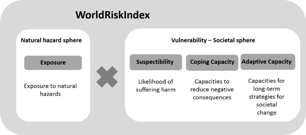
The concept of the WorldRiskIndex is referring to the understanding of risk within the natural hazards and disaster risk community, where disaster risk is defined as the product of the interaction of physical hazards and the vulnerabilities of exposed elements (UNISDR, 2004; Wisner et al., 2004; Birkmann 2006, IDEA 2005, IPCC 2012).
Data & Methods
The WorldRiskIndex clearly prioritises those hazards that are widely spread around the globe and account for major harm in terms of people killed. For the period of 1980 to 2010, the most frequent and devastating natural hazards reported were floods, storms, earthquakes and droughts, accounting for 81% of all events and 83% of all reported fatalities (see CRED EM-DAT 2012). Additionally, sea level rise was taken into account since it is very likely that due to further climate change sea level rise will affect many low laying coastal zones and delta regions, since already today 13% of the world population is living in coastal areas that are less than 10m above sea level (UNHABITAT 2011).
Exposure relates to physical exposure, which means the potential average annual number of individuals who are exposed to earthquakes, storms, droughts and floods (Peduzzi et al, 2009). These data were obtained from the PREVIEW-Global Risk Data Platform (http://preview.grid.unep.ch/), which is a multiple agency effort to share spatial data on global risk regarding natural hazards.
The calculation of exposure to sea level rise by one meter is based on data from the Center for Remote Sensing of Ice Sheets (CreSIS, 2011) at the University of Kansas and population statistics of the Global Rural-Urban Mapping Project (GRUMP) run by the Center for International Earth Science Information Network (CIESIN, 2012) at Columbia University and was derived by using GIS (Geographical Information System) methods.
![]()
Susceptibility (S)=(2/7*(0.5*(A+B))+(1/(7 )*C)+ (2/7*(0.5*(D+E))+(2/7*(0.5*(F+G))
Coping Capacity (CC)=(0.45*(0.5*(A+B)))+(0.45*(0.5*(C+D)))+(0.1*E)
Lack of Coping Capacity (LoCC)=1-CC
Adaptive Capacity (AC)=(0.25*(0.5*(A+B)))+(0.25*(0.5*(C+D)))+(0.25*(0.25*(E+F+G+H)))+0.25*(1/(3 )*(I+J+K)))
Lack of Adaptive Capacity (LoAC)=1-AC
WorldRiskIndex =E*((1/3)*(S+LoCC+LoAC)
Results & Maps (click to open interactive view)
Outreach
Birkmann, J., & Welle, T. (2016): The WorldRiskIndex 2016: Reveals the Necessity for Regional Cooperation in Vulnerability Reduction. In: Journal of Extreme Events, Vol. 3, No. 1, (21 pages).
Welle, T., & Birkmann, J. (2015): The World Risk Index – An approach to assess risk and vulnerability on a global scale. In: Journal of Extreme Events, Vol. 2, No. 1, (34 pages).
Birkmann, J. and T. Welle (2015): Assessing the risk of loss and damage: exposure, vulnerability and risk to climate-related hazards for different country classifications; International Journal of Global Warming 01/2015; 8 (No.2):191-212.
Birkmann, J. and T. Welle (2015): Assessing the risk of loss and damage: exposure, vulnerability and risk to climate-related hazards for different country classifications; International Journal of Global Warming 01/2015; 8 (No.2):191-212.
Welle, T., & Birkmann, J.(2015): Der WeltRisikoIndex 2015. In: WeltRisikoBericht 2015, HRSG. Bündnis Entwicklung Hilft und United Nations University-Institute for Environment and Human Security, pp. 41-49, ISBN 978-3-9814495-8-7 
Welle, T., Beck, M., Birkmann, J.: (2014): The Coasts at Risk Index. In: Coasts at Risk: An Assessment of Coastal Risks and the Role of Environmental Solutions. Edited by Michael W. Beck. A joint publication of United Nations University - Institute for Environment and Human Security (UNU-EHS), The Nature Conservancy (TNC) and the Coastal Resources Center (CRC) at the University of Rhode Island Graduate School of Oceanography. Published 2014.
Welle, T., Birkmann, J., Rhyner, J. (2014): Der WeltRisikoIndex 2014. In: WeltRisikoBericht 2014, HRSG. Bündnis Entwicklung Hilft und UNU, pp. 39-53, ISBN 978-3-9814495-3-2
Welle, T., Birkmann, J., Krause, D., Suarez, D.C., Setiadi, N. and J. Wolfertz (2013): The WorldRiskIndex: A concept for the assessment of risk and vulnerability at global/national scale. In: Birkmann, J.: Measuring Vulnerability to Natural Hazards: Towards Disaster Resilient Societies. Second Edition, pp. 219-251, United Nations University Press. ISBN-13: 978-92-808-1202-2
Birkmann, J., Cutter, S., Rothman, D., Welle, T., Garschagen, M., van Ruijven, B., O‘Neill, B., Prestion, B. L., Kienberger, S., Cardona, O.C., Siagin, T., Hidayati, D., Stetiadi, N., Binder, C., Hughges, B., Pulwarty, R. (2013): Scenarios for vulnerability: opportunities and constraints in the context of climate change and disaster risk. In: Climatic Change (online First). DOI 10.1007/s10584-013-0913-2
Welle, T., Birkmann, J., Rhyner, J., Witting, M. & Jan Wolfertz (2012): Worldriskindex 2012: Concept, Update and results. In: WorldRiskReport 2012, HRSG. Bündnis Entwicklung Hilft, pp. 11-27, ISBN 978-3-9814495-0-3
Birkmann, T. Welle, D. Krause, Jan Wolfertz, Dora Catalina Suarez & Neysa Setiadi (2011): Worldriskindex: Concept and results. In: WorldRiskReport 2011, HRSG. Bündnis Entwicklung Hilft, pp. 13-42, ISBN 978-3-9814495-0-1